ShopDreamUp AI ArtDreamUp
Deviation Actions


Suggested Deviants


Suggested Collections


You Might Like…


Featured in Groups


Description
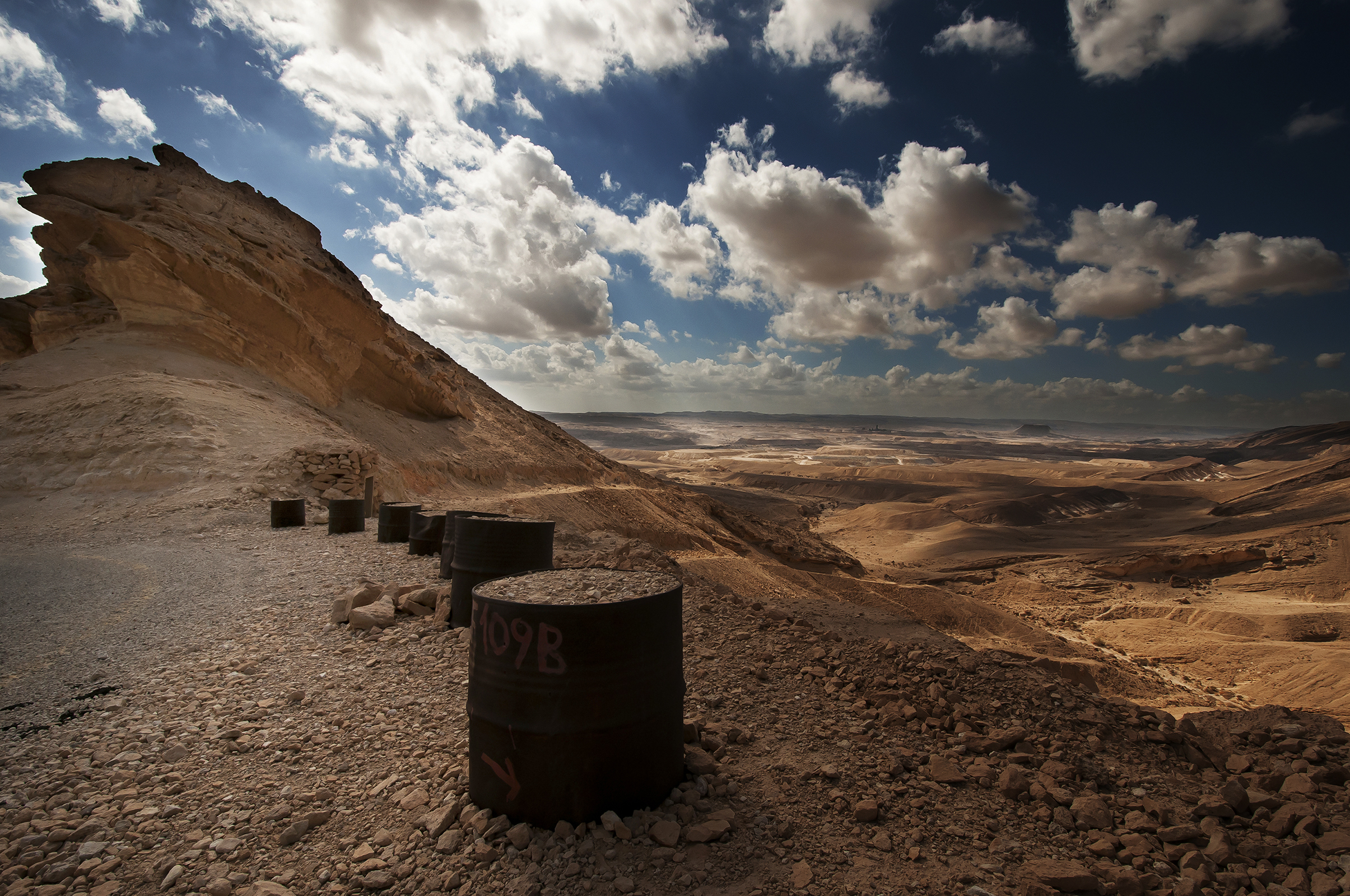
This is my Homeland .
The Negev (Hebrew: הַנֶּגֶב, Tiberian vocalization: han-Néḡeḇ ; Arabic: النقب al-Naqab) is a desert and semidesert region of southern Israel. The region's largest city and administrative capital is Beersheba (pop. 185,000), in the north. At its southern end is the Gulf of Aqaba and the resort city of Eilat. It contains several development towns, including Dimona, Arad and Mitzpe Ramon, as well as a number of small Bedouin cities, including Rahat and Tel as-Sabi. There are also several kibbutzim, including Revivim and Sde Boker; the latter became the home of Israel's first Prime Minister, David Ben-Gurion, after his retirement from politics.
The Negev covers more than half of Israel, over some 13,000 km² (4,700 sq mi) or at least 55% of the country's land area. It forms an inverted triangle shape whose western side is contiguous with the desert of the Sinai Peninsula, and whose eastern border is the Arabah valley. The Negev has a number of interesting cultural and geological features. Among the latter are three enormous, craterlike makhteshim (box canyons), which are unique to the region; Makhtesh Ramon, Makhtesh Gadol, and Makhtesh Katan.
The Negev is a rocky desert. It is a melange of brown, rocky, dusty mountains interrupted by wadis (dry riverbeds that bloom briefly after rain) and deep craters. It can be split into five different ecological regions: northern, western, and central Negev, the high plateau and the Arabah Valley. The northern Negev, or Mediterranean zone, receives 300 mm of rain annually and has fairly fertile soils. The western Negev receives 250 mm of rain per year, with light and partially sandy soils. Sand dunes can reach heights of up to 30 metres here. Home to the city of Beersheba, the central Negev has an annual precipitation of 200 mm and is characterized by impervious soil, known as loess, allowing minimum penetration of water with greater soil erosion and water runoff. The high plateau area of Ramat HaNegev (Hebrew: רמת הנגב, The Negev Heights) stands between 370 metres and 520 metres above sea level with extreme temperatures in summer and winter. The area gets 100 mm of rain per year, with inferior and partially salty soils. The Arabah Valley along the Jordanian border stretches 180 km from Eilat in the south to the tip of the Dead Sea in the north. The Arabah Valley is very arid with barely 50 mm of rain annually. It has inferior soils in which little can grow without irrigation and special soil additives.
Image size
2410x1600px 3.34 MB
Make
NIKON CORPORATION
Model
NIKON D300S
Shutter Speed
1/1250 second
Aperture
F/11.0
Focal Length
10 mm
ISO Speed
200
Date Taken
Oct 19, 2013, 11:12:08 AM
© 2013 - 2024 DaniBabitz
Comments35
Join the community to add your comment. Already a deviant? Log In
The very wide angle offers to the scene a dramatic and impressive visual impact.
The very wildeness of the place is emphasized by these columns, which push the watcher to question himself about their origins, and the human print in this desertic area.
Details revealed by the shadows of the clouds give a depth to the vision, and this field of depth VS the aperture (f11)allows to navigate deeply into the scene, and therefore encouraged me to dream and enjoy a quiet and peaceful moment as a witness of this landscape.
The shoot was taken in a great (and unkown for many of us) place, associated with a great sens of composition and technic.
The high contrast between the sky, its clouds, and the desert with the columns provoke eventually the emotion about how temporar we are as human beings, and what we live and leave behind us.